


OS Maps: Walk, Hike, Run, Bike
Ordnance Survey LtdDescription of OS Maps: Walk, Hike, Run, Bike
OS Maps is a mobile application designed for outdoor enthusiasts, providing tools for walking, hiking, running, and biking. This app serves as a comprehensive navigation tool that allows users to explore and plan their adventures across the UK and beyond. Available for the Android platform, users can download OS Maps to access a wide range of features catered to different outdoor activities.
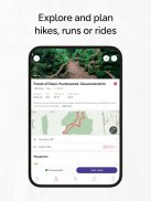
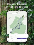
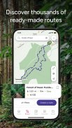
The app offers users the ability to create personalized routes tailored to their preferences, whether for a leisurely walk or an intense hike. With trusted mapping and navigation tools sourced from Ordnance Survey, Britain’s national mapping service, OS Maps ensures that users have access to accurate and reliable information when planning their outdoor excursions. Users can utilize the app to discover thousands of ready-made routes curated by outdoor experts, making it easy to find new paths to explore.
Route planning is a key aspect of OS Maps. Users can chart their own paths using quick and easy snap-to-path route plotting, which allows for efficient route creation. The interface is user-friendly, enabling both novice and experienced outdoor enthusiasts to navigate the app with ease. In addition, the app features a running route planner, which helps users find scenic trails suitable for their running activities. Cyclists can benefit from the cycle tracker, which enables them to log their rides and monitor performance over time.
OS Maps provides access to topographic mapping, which includes detailed elevation data and terrain information. This feature is especially useful for those who venture into more challenging environments. The app offers OS Explorer 1:25,000 and OS Landranger 1:50,000 maps, allowing users to choose the level of detail that best suits their navigation needs. Furthermore, the app has expanded its mapping capabilities to include global topographic mapping for regions such as the USA, Australia, and New Zealand, enabling users to explore new destinations worldwide.
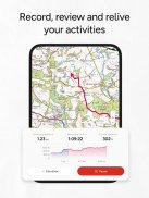
Users can save and share their planned routes with friends, making it easier to coordinate group outings or share favorite trails with others. This collaborative feature promotes social interaction among outdoor enthusiasts and enhances the overall experience. Additionally, the app allows users to log their activities, providing a comprehensive overview of their outdoor adventures and helping them track their fitness goals.
Battery life is an important consideration for users who rely on GPS features during their outdoor activities. OS Maps includes information about battery consumption, reminding users that continuous GPS use can significantly drain battery life. This guidance helps users plan their excursions effectively, ensuring they remain powered throughout their adventures.
OS Maps has established partnerships with organizations such as Mountain Rescue England & Wales, further emphasizing its commitment to safety and navigation accuracy in outdoor activities. The app has garnered recognition within the outdoor community, having been awarded "The Great Outdoor App of the Year" for seven consecutive years. This acknowledgment reflects the app's reliability and effectiveness as a navigation tool for outdoor pursuits.
The app's mapping technology is designed to provide clarity and precision, allowing users to feel confident when exploring unfamiliar areas. The curated routes from organizations like Trail, Country Walking, and Mountain Bike UK offer users diverse options for their outings, catering to various interests and skill levels. This extensive database of routes ensures that users can find suitable paths regardless of their activity of choice.
For those looking to immerse themselves in the beauty of the Great British countryside or explore new terrains, OS Maps serves as a valuable companion. The tools provided within the app support users in discovering hiking routes, walking paths, cycling trails, and more, encouraging outdoor exploration and physical activity.
Incorporating user feedback is a priority for OS Maps, with ongoing updates aimed at enhancing app stability and adding new features. This responsiveness to user needs reflects the developers' commitment to delivering a high-quality experience for outdoor enthusiasts.
Whether planning an adventure or simply seeking inspiration for a new route, OS Maps offers the features needed to navigate and enjoy the outdoors confidently. With its extensive mapping capabilities, route planning tools, and user-friendly interface, the app serves as an essential resource for anyone looking to engage with nature. Users can explore the joy of the outdoors while utilizing the trusted navigation features provided by OS Maps.
For additional information, you may visit os.uk/termsosmaps.
OS Maps: Walk, Hike, Run, Bike - Version 5.3.6.1366
(03-02-2025)OS Maps: Walk, Hike, Run, Bike - APK Information
APK Version: 5.3.6.1366Package: uk.co.ordnancesurvey.osmapsLatest Version of OS Maps: Walk, Hike, Run, Bike
Other versions


Apps in the same category


